Monday December 17, 2007 - Open letter to Sec- General of UN - Think Global Warming is a factually sound concept since Al Gore received the Nobel Prize? As you know I've said its not man-made and now the real experts of the world agree in an open letter to the Sec-General of the United Nations..........read the text of the open letter and the signatories here.
Monday September 4, 2007 - 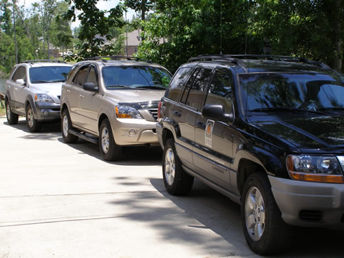 I
have recently added two new storm chase vehicles to the operation - two
brand new Kia Sorento's (one EX and one LX) are now fully functional for
chasing. The gear layout is smaller and more efficient - call it the change
in technology over the past three years. Our jeep is going to transfer
to our west coast operation in Seattle.
I
have recently added two new storm chase vehicles to the operation - two
brand new Kia Sorento's (one EX and one LX) are now fully functional for
chasing. The gear layout is smaller and more efficient - call it the change
in technology over the past three years. Our jeep is going to transfer
to our west coast operation in Seattle.
Took a spike off a lightning bolt Sunday evening.....the main bolt went down the power pole by the street, which just happens to sit under a 120 foot pine tree....the spike hit the WIFI external antenna which is only 15 ft off the ground, but near another 100 foot pine tree by the lake. Grounding system worked as designed - however the wifi transmitter was toast and the 16 port hub failed. Also lost one on board NIC but was able to replace with a network card in a slot. So after a new transmitter and two 5 port hubs the system was back operational after only 45 minutes. (Thanks for a nearby late night Walmart). Some fine tuning on Monday Labor Day had everything again at optimum. Also did some lubrication work to the Lacrosse anemometer which was giving poor readings - so thats fixed now as well.
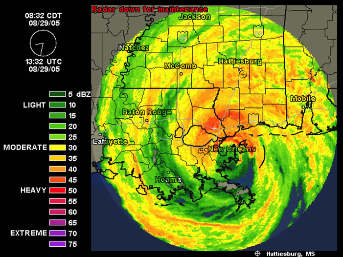 Wednesday
August 29, 2007 - 2nd Anniversary of Katrina - No possibility
of letting today go by without some comments on this second anniversary
of Katrina......It has taken 2 years just to catch up on damage repairs
around here and to begin to start moving ahead - and this 60 miles inland
from the Mississippi Coast! There is still plenty of evidence of the constant
fight between people and their respective insurance companies...still
blue tarps up and lots of abandoned buildings.
Wednesday
August 29, 2007 - 2nd Anniversary of Katrina - No possibility
of letting today go by without some comments on this second anniversary
of Katrina......It has taken 2 years just to catch up on damage repairs
around here and to begin to start moving ahead - and this 60 miles inland
from the Mississippi Coast! There is still plenty of evidence of the constant
fight between people and their respective insurance companies...still
blue tarps up and lots of abandoned buildings.
Even U.S. Congressmen are not back in their own houses two years after the event due to insurance companies - it just astounds me that for decades people paid their premiums in good faith thinking they were covered - and the banks thinking they were covered too since everyone with a mortgage has to have insurance coverage. So would someone explain to me how a whole population and those people that finance them and those individuals who write and pass our laws, can all be on the wrong side of fence just because an insurance company doesn't want to pay? Signs still exist on the coast that state "Katrina an act of God, State Farm an act of the Devil". Take a drive along the coast and see the large number of homeless people living on the street - there were none before Katrina. Take a look at the rebuilding efforts along the coast - oh you don't see any? Probably because there is almost none. Sure a few casinos have been reopened and there is lots of talk about a booming economy in the future - HALT - take a real look. Casinos have employees and employees need reasonably priced housing - there is none and the coast of rebuilding is not going to allow that to happen. The only people that can rebuild are those that have tons of money and are not counting on insurance payments. With that type of money they aren't going to be working at the casinos. Don't think that's and issue? - will just because your house got blown away and you didn't get a replacement payment from the insurance companies, doesn't mean you have to stop paying your mortage!
The fact of the matter is that after two years we have a coastline in Mississippi with little recovery - the city of New Orleans that must have close to a hundred square miles lying in ruins - and lots of promises of Federal help but payments few and far between (all talk and no action - must be talking about FEMA eh?). Where are all those billions promised? Not here. History will show that people will remember who helped and who were just talking; and insurance companies like State Farm?.......you should have made the payments because the number of people across the country that will not do business with you in the future will be a thousand times higher than what should have been paid out in the first place. People remember these things - if they have a need to change their insurance company in the future they will pick anyone other than the names they remember for NOT paying. Instead of costing millions its quite likely to run you out of business in the long run.
Think of any major city in this county and take out half of it with a storm and not pay those damage payments that people pay in good faith - thats what you have on the Gulf Coast - would Americans let this happen to their town (Tacoma, WA or LA or Chicago or Boston)??? well this is what you have here - so if it can happen here do you really think it will be different where you live? You need to do some deep soul searching about this and then ask your politicians why they allow insurance companies to operate with misrepresentation; ask your politicians how we can have people homeless two years after an event and all they can talk about is it takes time; ask your politicians how this has come to pass in America and why nothing is being done to correct the situation. It is truly a disgrace that is clearly visible to the rest of the world. It is hard to go around the world saying we care as a people about your plight when we don't take care of our own.
This blog entry is not meant to be speech but to make you think and take action now - because this can happen anywhere and probably will. Mother Nature just doesn't really ask us about what we want.
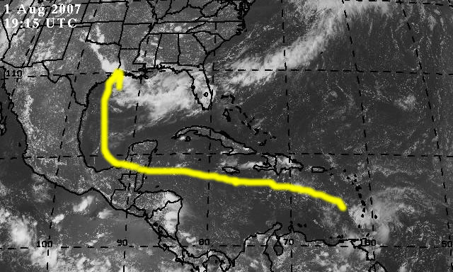
Saturday August 11, 2007 - Today marks
13 years on the internet with webpages for the operation and marks 4 years
of being in Southern Mississippi. Hot today over 101F as this is being
written. Lots of development attempting in the Gulf and Carribean with
the most interesting area being rotation off the Florida coast. 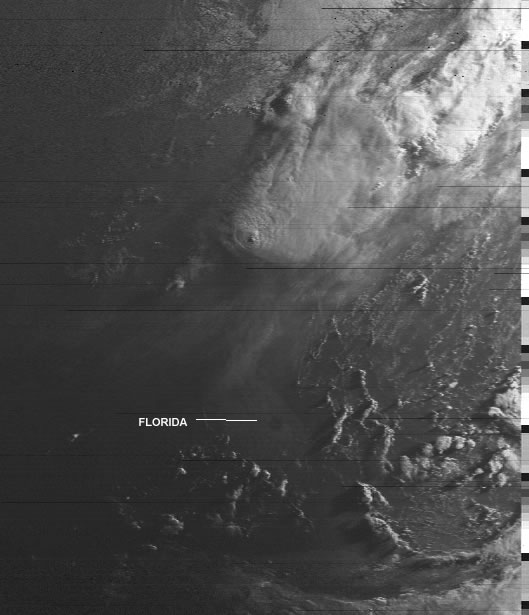 The
620am polar sat photo shows the circle off the east coast just as the
sun was coming up.The weather system affecting the NE of the country is
in the NE corner of the photo. The next area of concern is south of Jamaica
but still remains pretty disorganized. Most likely we shall see interaction
with the rotation off Florida. An area of similar rotation was off the
NW side of the Yucatan yesterday but has moved up the coast towards Texas.
Most of the circulation is over land. The fourth area of concern is a
tropical wave that has moved off of Africa and is heading west. I expect
this to be a named storm within 36 hours. As one might expect it would
take a week to be in our general vicinity if it maintained direction -
a pretty big if at this stage of the game but we shall see what happens.
The biggest concern is the excessive heat - it is going to continue to
heat the Gulf which is just a hair under 88F at the moment....an important
factor because the next week is going to be the same - brutal. It is this
type of heat that fuels the weather engine.
The
620am polar sat photo shows the circle off the east coast just as the
sun was coming up.The weather system affecting the NE of the country is
in the NE corner of the photo. The next area of concern is south of Jamaica
but still remains pretty disorganized. Most likely we shall see interaction
with the rotation off Florida. An area of similar rotation was off the
NW side of the Yucatan yesterday but has moved up the coast towards Texas.
Most of the circulation is over land. The fourth area of concern is a
tropical wave that has moved off of Africa and is heading west. I expect
this to be a named storm within 36 hours. As one might expect it would
take a week to be in our general vicinity if it maintained direction -
a pretty big if at this stage of the game but we shall see what happens.
The biggest concern is the excessive heat - it is going to continue to
heat the Gulf which is just a hair under 88F at the moment....an important
factor because the next week is going to be the same - brutal. It is this
type of heat that fuels the weather engine.
The important thing to remember is that while many areas of concern may get mentioned in discussions most of the areas will not develop further - energy can fail to materialize that takes development to the next level in hours. So be hurricane prepared but don't panic. Going nuts can be more dangerous than any storm. I know many of us are a little gun shy since Katrina but there are some things in this world than we can change and some we can't - think of everything as one giant learning experience. Also realize that in the two years since Katrina that we as a people have learned a whole lot about survival and implemented changes for the better. It was the spirit of the people that kept us going forward the last time and it will be the better prepared spirit this time that will get us through anything in the future.
For those of you that have a problem reading the ticker tape here is todays content:
Sat 120pm - temp 101.3F heat index 113.1F - HEAT ADVISORY IN EFFECT - HOT HOT HOT.....Expecting development...area just east of the Florida with rotation (see sat pic in blog)....Monitoring area in Atlantic just off coast of Africa which is most likely going to be storm within next 36 hours....Monitoring area just south of Jamaica...area with heavy rotation nw of the Yucatan is moving NW over land....heat will continue unabated with occasional popup thunderstorms for several days...Get the latest weather warnings on this website and your NOAA weather radio.......
Thurday August 9, 2007 - Heat wave continues across the south with temps near 100F and heat index at 116 as this is being written. A few clouds in the Carribean east of Jamaica but little else underway. I've been fine tuning the fan and airflow in the control room to keep gear stable - rather difficult task but will improve with the addition of insulation on the walls this fall. On evenings where the AC catches up I usually am keeping in touch with the various ARES Ham radio networks in southern Mississippi and Alabama. The ham station area is bearable with the fans and AC most of the time and the fine tuning has made a difference. For those that are interested in ham radio you might be interested in the antenna section for my station KE5JJC. The pics are located here.
Monday August 6, 2007 -
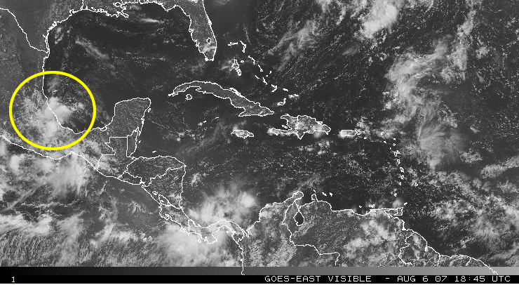
Six days later and our path of the 99I wave has been right on the money. Currently what is left is small and over land. The remains will probably drift northward over land as opposed to our initial plot over water.
Word on the street is the hurricane experts are now lowering the number of predicted storms for the season. Frankly not a whole lot looks different from last year as far as wind shear areas so I always thought the predictions were off from the getgo. What is of interest is that while its hot hot at the moment the overall feel of weather for the past month has been fallish as opposed to a long slow summer. Maybe its the change of the 11 year sun spot cycle to a fresh cycle. However it may be basic physics - extremes of highs and lows have existed these past few months over much of the world. Its those extremes that mother nature attempts to moderate but in order to moderate alot of energy must change hands and locations. So if things are heading to fall "early" then that would mean there is a lot of energy changing hands - or about to change. It's totally unscientific to use the terms feel - but something tells me while we may not have a lot of big storms we may have a lot of weather - and that may be what we need to be prepared for. Energy must change hands and it may do so in a variety of ways - heavy rains, lots of fronts, or temperature changes from one extreme to another. Its common practice to say that the seasons really start a month before the calendar date. This year we may even be ahead of the month period by several weeks. Only time will tell.
Wedneday August 1, 2007 - 3:30pm -
Wed 3:30 - TRACKING 99I (Dean or Erin?) Pressure 1002mb Latest Position
12.1 58.4W Maximum Winds 30 mph Moving West at 20 mph....Now located over
southern Windward Islands....this system will probably gain tropical depression
status within 24 hours or less...Arrival in our general area (the Gulf)
middle of next week based on current rate of travel...Suggest ensuring
supplies are in house as early prep......Front hanging over LA and the
Gulf and back up the Atlantic seaboard is still touching off numerous
popup thunderstorms...A low pressure area continues to build in the Gulf
off the Mississippi and Alabama shorelines (Dean or Erin?)....needs to
be watched.....Get the
latest weather warnings on this website and your NOAA weather radio.......Our
earliest projection:
Tuesday July 10, 2007 - 9:46pm - Latest analysis shows developing Tropical Storm off Cape Hatteras.....
 Current airflow would bring storm south and back into the gulf. If storm
development continues the storm will strengthen on the route probably
developing hurricane status.
Current airflow would bring storm south and back into the gulf. If storm
development continues the storm will strengthen on the route probably
developing hurricane status.
The latest updates to the center's computers were put into place over this past weekend. Cameras have been restored on a different server. The modifications continue to build our operation to one of the most advanced in the south.
Thursday June 21, 2007 - I've said for years there are
only two seasons in the year - summer coming and summer going. So here
we are at midpoint once again. For those of you following the man-made
global warming debate here is a link to the opposite and more scientific
analysis of reality on our planet: http://www.canada.com/nationalpost/financialpost/comment/story.html?id=597d0677-2a05-47b4-b34f-b84068db11f4&p=4
Here you will find a series of articles that should open up your eyes.
The fact is mother nature doesn't really care about the economy or national
boundaries and good science is still good science. We need more real scientists
who deal with the facts rather than emotions.
Control room here in Petal has doubled in size. I've also added a 50ft tower with a 17foot vhf/uhf antenna for ham communications - the system currently ties in Jackson, Meridian, Mobile, and New Orleans plus a slew of other repeaters.
Hurricane season is here again - the UK group is predicting only 10 named storms....a figure that I would say is probably more accurate than the 17 predicted from other sources. So far there has been a lot of wind shear similar to last year. On the other hand mother nature doesn't talk to me and let me know whats up so things could be totally different.
High winds this week from a tstorm squall line caused numerous power outages (including our location for 6 hours)....a microburst is responsible for the damage. While a super cell embeded in the line was directly on course for our Petal location conditions did not develop for a tornado.
Currently monitoring the Gulf for development. Also we have added new Goes Sat pic links as well as local visible and IR sat pics. You will also find updated information in the master doc pages; and several new links for pda and cell phone internet conections.
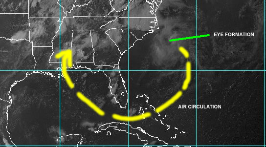
Sunday April 6, 2007 - Counterclockwise circulation on a developing preseason tropical strom is interacting with the storm in the midwest....talk about a flow of moisture and energy......stay tuned....this may be most interesting. Here is the 7pm water vapor capture showing the interaction:

Saturday May 5, 2007 -
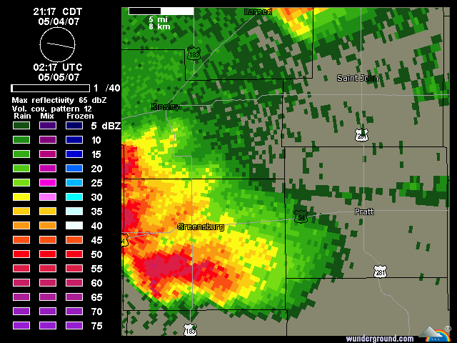
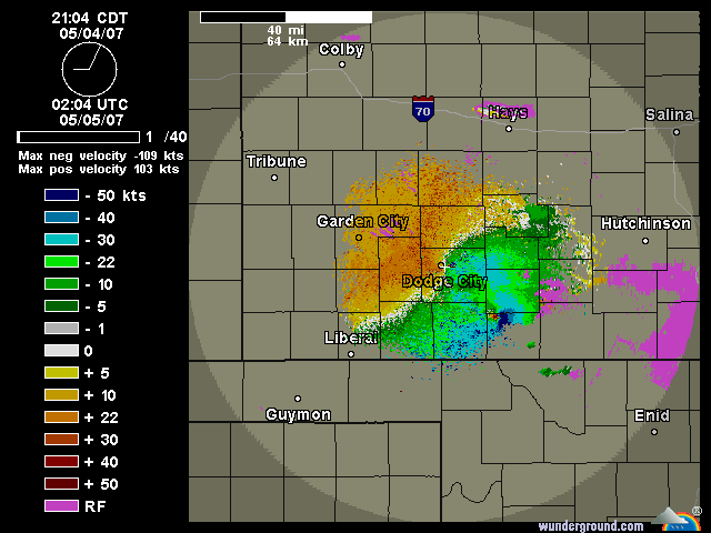
Radar and Velocity captures of the nearly mile wide tornado that destroyed Greensburg, Kansas last night. Its not often one sees a tornado of this size so clear on radar.....and of course very little defence in this case.
New gear going online by the end of the month....several new computers and systems will be functioning in time for the start of the June 1st hurricane season.....which in fact may be a little off the mark since there appears to be circulation off the Carolina coast that resembles a tropical storm in formation. So I don't think one can emphasize to much that this year is not going to be a repeat of 2006...there are no steering currents in place this year which kept storms at bay last year. In fact initial conditions on both the pacific side and the atlantic show lots of energy. How things develop will depend on the amount of energy from the sun but there does seem to be a strong move in a summer with lots of activity.
Also movement has been made for improved communication from the weather facility to the outside world and with a little luck packet radio transmission of weather data may be online by July. One more ham operator in the group now in Seattle - Dave Davis - KE7MYS...congrats Dave!
Thursday April 5, 2007 - COBWEBS - finally did some maintenance today....inaccurate wind speed readings (there were none) and improper rain gauge amounts a few days ago prompted the take the gear apart and examine routine. Cobwebs....its amazing how they can be so small yet stop devices completely - and that is exactly what I found. So I've cleaned out the gauges and they should be back working normally now. BTW if you see rain today its simply the cleaning of the device - no rain. The instrumentation is located on a pole at the end of the dock out in the lake - its hot in the daytime and near fish at night but that does not seem to slow spiders down....there are webs all over the place. I'm going to have to see what is environmentally sensitive but will solve the problem.
Latest news out of NASA and the US Geological folks is that Mars is experiencing global warming. Gee I didn't realize that man had already colonized the place and screwed it up. Geewhiz could Al Gore be wrong?
Work continues on the new ham radio 50 foot mast that will house the 17 foot multiband antenna - overall height at the top 67 feet. Since this locaiton is on a hill at 275 feet that should make the line of sight transmissions rather considerable. My purpose is to ensure good communications between Jackson and the coast well in time for the hurricane season. Coax is in place and the antenna has arrived so operations should be a go within two weeks weather permitting.
The lake cam server is currently down due to a recent nearby lightning hit.....I'll be looking at the situation over the next few days to see if a cure can be implemented. Note the cam server has been running on port 80 and the weather servers on port 85... I may make a switch on these ports as many locations have non 80 ports blocked and the main purpose of this operation is to ensure that data gets to the most people quickly and without issues.
This weekend is supposed to be rather cool with the possibility of frost in some locations....I hope not as my garden is doing rather well.
P.S. the Wefax messages which are received from the New Orleans transmitters appears to be doing the same process as last year at this time.........no transmissions being received here. This happened last year during this same time period....checking with their website shows no indication that the transmitter is off air....nor did it last year. And frankly I doubt very much that its a reception problem being its literally 100 miles or less to the antennas. You can access the messages on their website....check out the link on the master page.
Wednesday March 21, 2007 - Trees have popped out the last few days here as the weather has been warm and dry. The Glenda Project now holds Patent number 60/903,881 - Multi Dimensional Data Models for Tornado Prediction, which reflects our unique work in atmospheric research and goals. Our system has been used for predictions which have been 100% accurate of recent....a most unique accomplishment in the weather field.
Thursday March 1, 2007 - A day of numerous tornados across the south - we gave a weather forecast at 5 am on the website indicating severe thunderstorms with tornados would continue to develop across SE MS and AL - the ironic part was the NWS missed this entirely..... the end of the day has at least 13 dead from a school being destroyed in .....AL just over the line from SE MS. Several lines of storms came through the Petal area including one with a firm radar contact for a tornado. The tornado tracking east from Columbia through West Hattiesburg and then across Petal into Jones County......confirmed with visual in West Hattiesburg, radar confirmation at I59 and Hardy St....and with the path within range of our Weather Facility here in Petal the webcams were being monitored off location while talking on location. While monitoring the webcams luck of the draw caught the tornado actually up in the air coming over the lake..........A quick screen capture managed to grab the event:
This is the screen capture (click on pic for larger version) :

This is Video 1 Blown up 200% - not enhanced:

This is the legend for the pic so you know what you are looking at:

This is an enhanced color modified version:

Here is the log of baro, etc:

Thursday, February 22, 2007 -  Finally
got a chance to see the article
about the Glenda Project which appeared in the Petal Profile for 2007
(Feb 8 publication date). This article gives a little insight into how
we arrived in Mississippi with this project. This past week Feb 22nd saw
our weather presentation to the Lamar Park Amateur Radio Club. The presentation
is intended to open a few eyes to the viewpoint of not accepting the status
quo and using hard science for learning - of course coupled with a little
fun. As the presentor, you get my perspective in this presentation.
A similar presentation will be given to the Magnolia DX Club meeting on
March 10th in Gulfport.
Finally
got a chance to see the article
about the Glenda Project which appeared in the Petal Profile for 2007
(Feb 8 publication date). This article gives a little insight into how
we arrived in Mississippi with this project. This past week Feb 22nd saw
our weather presentation to the Lamar Park Amateur Radio Club. The presentation
is intended to open a few eyes to the viewpoint of not accepting the status
quo and using hard science for learning - of course coupled with a little
fun. As the presentor, you get my perspective in this presentation.
A similar presentation will be given to the Magnolia DX Club meeting on
March 10th in Gulfport.
May 19th, 2007 at the Pendleton Airport in Pendleton, Oregon will be a demonstration for NWS/NOAA, of the latest Thunderockets in use by the Glenda Project. This demonstration is open to the public. The Thunderocket demonstration launches will show the latest telemetry capsules and capture systems as well as the new Ranger Interceptor unit designed for full data capture, live telemetry, and live video from the heart of severe storms and tornados. Dave Davis and Tim Quigg will both be on hand for the demonstration and to answer any questions that you may have.
Sunday, February 11, 2007 - Today marks the completion of a year since the LaCrosse weather station was put on the internet. As you can tell from the past blog entries there was one section where we returned the unit to LaCrosse for repair, and if you examine the data you can see our biggest complaint - data readings that appear at random out of the blue. Basiclly support from LaCrosse was poor - they basically blamed the installation rather than their product. Sometime in the next few months we will replace the unit with another brand with better stability. Anyhow the weatherunderground.com collects the data we send and below is a chart of the past year:
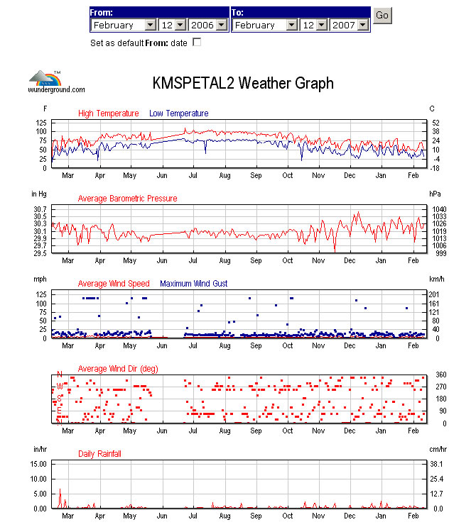
The high temperature was 108F and the low as I recall around 21F. The chart shows the June period where the unit was in repairs.
The new routers have been installed on the network in Petal (giga speed now) - this allows for better flow of data and presents a stronger firewall to the outside world. As one might expect the constant barrage of viruses, worms, and attacks continues from different locations around the world....these people really need to get a life.
The 3D readings of the EMF are online; radiation readings should be online
soon. Still implementing improvements on data access times to real time
delivery for the web. Also a new 50 foot mast has arrived for the 2 meter
ham installation to improve communications. The current timetable is for
activation with a new antenna around mid-March. This should allow simplex
communication from the Gulf Coast to Jackson.
Thursday, January 26, 2007 - The website continues to be modified
to improve access to information. You will now find an expanded link section
(separate from the local links section) which is part of the Glenda Project
website. Word from the west coast is that the new Thunderocket model will
be launched from the new Camano Island site sometime in March. Look for
a Pacific Coast Weather section soon in the Chase area of the website.
A recent article in the Stone County (MS) Enterprise highlights the importance of ham radio in SKYWARN activities. You can read the article which mentions our center here.
Interference on the EMF reception system at night was isolated this week to a faulty starter on a private security light about 500 feet from the center. The problem had been becoming progressively worse over the past couple of weeks. Dixie Electric resolved the problem the same day once the issue had been identified.
As of January 21th the center is now equipped with a 2 meter amateur radio base station. In order to get on the air we have installed a small ground plane antenna supplied by Larry Morgan (AG5Z) (visit his great ham site at http://larrysstuff.com). The new system allows communication to the Gulf Coast and up to Jackson, MS over the ham repeater network. KE5JJC our my call letters when I man the station.
Look for more online data feeds in the next few weeks. With the Katrina cleanup finally out of the way and the Christmas holidays past, there is finally time to move forward on the various systems and pickup where we should have been a year and a half ago. All we need now is some warmer weather!
Friday, January 5, 2007 - Sometimes knowing what will happen is tough to take when you see the results of a prediction. Thursday night was one of those nights that all the precursors were in place for tornados. In fact our Pullman Point Research Facility equipment was registering the full energy potential. When the first tornado watch was posted by the NWS, I had already established that everything was in place for this to happen. With the official word on the books an email was sent out to members of the Stone County ARES group with whom work has been done to help establish emergency ham communications. As a member of that group I specifically contacted Tim Purvis in Wiggins (45 miles to the south) and we discussed the readings on the various displays of information. Wiggins is far enough south of Petal to get a different weather pattern but this was one night that everything looked the same. After an hour of discussion ending around 9pm it was decided that the next major phase of bad weather would drop in between 12 midnight and 1AM. While it is unusal at this time of year for really severe weather the expectation was we could have major problems. At 12:30AM a tornado dropped out of the sky over western Wiggins and hit the ground in the center of town and continued to move to the NE and then back up into the air. This was one of several tornados which dropped across southern Mississippi. SEE THE TORNADO TRACK HERE. The Wiggins tornado was of special importance this time round as it destroyed the very building that held the ARES group meetings...meetings held for emergency management communication development. It just goes to prove that one can never to be too ready too fast. To look at the damage of the Wiggins tornado click on here. You can read the related text news story and view the report on Mobile Channel 5 WKRG TV.includes my 10 seconds of fame.